Title:
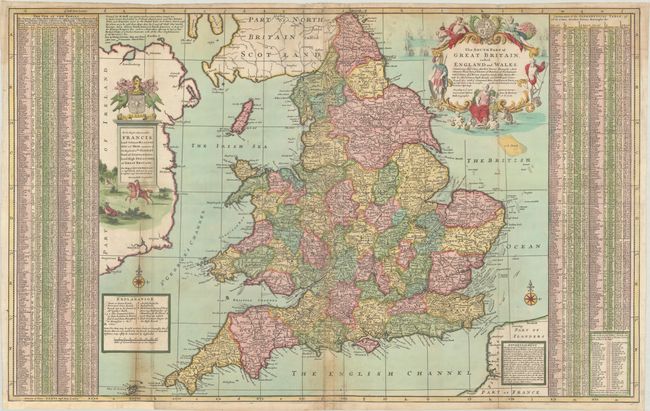
“The South Part of Great Britain, Called, England and Wales. Containing All ye Cities, Market Towns, Boroughs: and Whatever Places Have ye Election of Members of Parliament...”
Map Maker:
Herman Moll
This large and finely engraved map features remark... (full text available to subscribers)
| Item Detail |
| |
| |
MapMaker: |
Herman Moll
|
|
| |
| |
Subject: |
England & Wales |
|
| |
Period/Size: |
1710 / 24.1" x 38.5" (61.3 x 97.8 cm)
|
|
| |
Color: |
Colored
|
|
| |
Condition: |
(B) On a sturdy sheet of watermarked paper with light toning along the folds and a number of fold separations that have been archivally repaired on verso. There is a repaired edge tear that extends 1.5" into the image at bottom, and a small section of th (condition help) |
|
| |
Source: |
|
|
| |
References: |
|
|
| |
|
|
| Sales Information |
| |
| |
Price: |
|
|
| |
| |
Offered by: |
Old World Auctions |
|
| |
Catalog: |
Auction No. 193 - Antique Maps, Charts, Atlases & Globes (9567) |
|
| |
Lot/Item #: |
419 |
|
| |
| |
Date: |
07/2023
|
|
| |
| |
|
Antique Maps - Valuation and Pricing, Descriptions, Resources |
|
Home |
Information |
Search |
Register |
Contact Us |
Site Map
Americana Exchange, Inc. © 1999 - 2024 Americana Exchange, Inc.. All rights reserved.
OldMaps.com, the OldMaps.com logo and
AMPR are service marks or registered service marks of Americana Exchange, Inc..
|