Title:
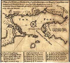
“A Plan of the Town and Harbour of Louisbourg in the Ifland of Cape Breton: Taken from ye French on June 17, 1745 by ye New England men under ye Command of General Pepperell, assisted by ye British Fleet commanded by Admiral Warren”
Map Maker:
Emanuel Bowen
Shows the town of Louisburg and the Fortress Louis... (full text available to subscribers)
| Item Detail |
| |
| |
MapMaker: |
Emanuel Bowen
|
|
| |
| |
Subject: |
Canada, East |
|
| |
Period/Size: |
1744 / 5.4" x 5.9" (13.7 x 15.0 cm)
|
|
| |
Color: |
Black & White
|
|
| |
Condition: |
Strong, uncolored impression. Cropped to margins. Very good condition. (condition help) |
|
| |
Source: |
|
|
| |
References: |
|
|
| |
|
|
| Sales Information |
| |
| |
Price: |
|
|
| |
| |
Offered by: |
Heritage Map Museum |
|
| |
Catalog: |
Antique Map Auction - June 2001 (235) |
|
| |
Lot/Item #: |
200 |
|
| |
| |
Date: |
06/2001
|
|
| |
| |
|
Antique Maps - Valuation and Pricing, Descriptions, Resources |
|
Home |
Information |
Search |
Register |
Contact Us |
Site Map
Americana Exchange, Inc. © 1999 - 2024 Americana Exchange, Inc.. All rights reserved.
OldMaps.com, the OldMaps.com logo and
AMPR are service marks or registered service marks of Americana Exchange, Inc..
|