Title:
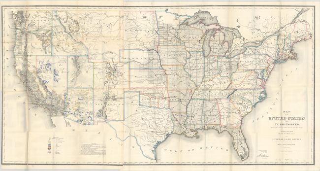
“Map of the United States and Territories. Shewing the Extent of Public Surveys and Other Details Constructed from the Plats and Official Sources of the General Land Office...”
Map Maker:
General Land Office
This map is one of the more remarkable maps produc... (full text available to subscribers)
| Item Detail |
| |
| |
MapMaker: |
General Land Office
|
|
| |
| |
Subject: |
United States |
|
| |
Period/Size: |
1866 / 28.5" x 55.3" (72.4 x 140.5 cm)
|
|
| |
Color: |
Colored
|
|
| |
Condition: |
(B) A colorful example with a number of fold separations mostly at the fold junctions, most of which have been closed on verso with tape. There are two binding tears (4" and 3") at left that have also been repaired with tape on verso. Issued folding. (condition help) |
|
| |
Source: |
|
|
| |
References: |
Phillips (Atlases) #1388-23; Wheat (TMW) #1137. |
|
| |
|
|
| Sales Information |
| |
| |
Price: |
|
|
| |
| |
Offered by: |
Old World Auctions |
|
| |
Catalog: |
Auction No. 193 - Antique Maps, Charts, Atlases & Globes (9567) |
|
| |
Lot/Item #: |
137 |
|
| |
| |
Date: |
07/2023
|
|
| |
| |
|
Antique Maps - Valuation and Pricing, Descriptions, Resources |
|
Home |
Information |
Search |
Register |
Contact Us |
Site Map
Americana Exchange, Inc. © 1999 - 2024 Americana Exchange, Inc.. All rights reserved.
OldMaps.com, the OldMaps.com logo and
AMPR are service marks or registered service marks of Americana Exchange, Inc..
|