Title:
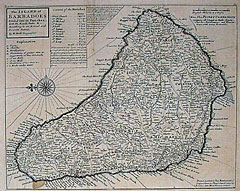
“The Island of Barbadoes. Divided into its Parishes, with the Roads, Paths, & c. According to an Actual and Accurate Survey.”
Map Maker:
Herman Moll
A large, detailed view of Barbados. Land owners li... (full text available to subscribers)
| Item Detail |
| |
| |
MapMaker: |
Herman Moll
|
|
| |
| |
Subject: |
Barbados |
|
| |
Period/Size: |
1705 / 11.5" x 14.4" (29.3 x 36.6 cm)
|
|
| |
Color: |
Black & White
|
|
| |
Condition: |
A few extra soft folds not readily discernable. 1" tear on bottom right margin not affecting image. (condition help) |
|
| |
Source: |
|
|
| |
References: |
|
|
| |
|
|
| Sales Information |
| |
| |
Price: |
|
|
| |
| |
Offered by: |
Heritage Map Museum |
|
| |
Catalog: |
Antique Map Auction - December 2000 (256) |
|
| |
Lot/Item #: |
|
|
| |
| |
Date: |
12/2000
|
|
| |
| |
|
Antique Maps - Valuation and Pricing, Descriptions, Resources |
|
Home |
Information |
Search |
Register |
Contact Us |
Site Map
Americana Exchange, Inc. © 1999 - 2024 Americana Exchange, Inc.. All rights reserved.
OldMaps.com, the OldMaps.com logo and
AMPR are service marks or registered service marks of Americana Exchange, Inc..
|