Title:
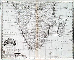
“A New & Accurate Map of the Southern Parts of Africa Containing Lower Guinea, Monoemugi, Zanguebar, the Empire of Monomotapa, County of the Cafres &c. and the Isld. of Madagascar”
Map Maker:
Emanuel Bowen
Ornate title cartouche at the lower left with vign... (full text available to subscribers)
| Item Detail |
| |
| |
MapMaker: |
Emanuel Bowen
|
|
| |
| |
Subject: |
Africa, South |
|
| |
Period/Size: |
1747 / 16.8" x 13.6" (42.6 x 34.6 cm)
|
|
| |
Color: |
Black & White
|
|
| |
Condition: |
Very faint age toning along the vertical centerfold, otherwise very good to fine condition. (condition help) |
|
| |
Source: |
|
|
| |
References: |
Norwich, 170. |
|
| |
|
|
| Sales Information |
| |
| |
Price: |
|
|
| |
| |
Offered by: |
Heritage Map Museum |
|
| |
Catalog: |
Antique Map Auction - June 2001 (235) |
|
| |
Lot/Item #: |
300 |
|
| |
| |
Date: |
06/2001
|
|
| |
| |
|
Antique Maps - Valuation and Pricing, Descriptions, Resources |
|
Home |
Information |
Search |
Register |
Contact Us |
Site Map
Americana Exchange, Inc. © 1999 - 2024 Americana Exchange, Inc.. All rights reserved.
OldMaps.com, the OldMaps.com logo and
AMPR are service marks or registered service marks of Americana Exchange, Inc..
|