Title:
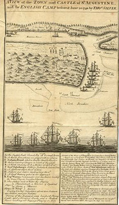
“A View of the Town and Castle of St. Augustine, and the English Camp before it June 20 1740”
Map Maker:
Thomas Silver
Bird's eye view with ships in foreground. Key and... (full text available to subscribers)
| Item Detail |
| |
| |
MapMaker: |
Thomas Silver
|
|
| |
| |
Subject: |
Florida, St. Augustine |
|
| |
Period/Size: |
1740 / 11.5" x 6.5" (29.3 x 16.6 cm)
|
|
| |
Color: |
Black & White
|
|
| |
Condition: |
Cropped past the neat line at top and lower right margins. Folds as issued. Very good condition. (condition help) |
|
| |
Source: |
|
|
| |
References: |
|
|
| |
|
|
| Sales Information |
| |
| |
Price: |
|
|
| |
| |
Offered by: |
Heritage Map Museum |
|
| |
Catalog: |
Antique Map Auction - December 2000 (256) |
|
| |
Lot/Item #: |
|
|
| |
| |
Date: |
12/2000
|
|
| |
| |
|
Antique Maps - Valuation and Pricing, Descriptions, Resources |
|
Home |
Information |
Search |
Register |
Contact Us |
Site Map
Americana Exchange, Inc. © 1999 - 2024 Americana Exchange, Inc.. All rights reserved.
OldMaps.com, the OldMaps.com logo and
AMPR are service marks or registered service marks of Americana Exchange, Inc..
|