Title:
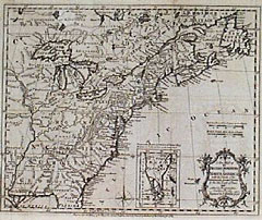
“A New Map of the British Dominions in North America with the Limits of the Governments annexed thereto by the late Treaty of Peace, and settled by the Proclamation, October 7th, 1763”
Map Maker:
Thomas Kitchin
Engraved folding map. It is of special interest in... (full text available to subscribers)
| Item Detail |
| |
| |
MapMaker: |
Thomas Kitchin
|
|
| |
| |
Subject: |
Colonial North America |
|
| |
Period/Size: |
1763 / 1764 / 11.0" x 9.5" (28.0 x 24.2 cm)
|
|
| |
Color: |
Black & White
|
|
| |
Condition: |
Some very faint transfer, otherwise very good. (condition help) |
|
| |
Source: |
|
|
| |
References: |
|
|
| |
|
|
| Sales Information |
| |
| |
Price: |
|
|
| |
| |
Offered by: |
Heritage Map Museum |
|
| |
Catalog: |
Antique Map Auction - September 1999 (250) |
|
| |
Lot/Item #: |
|
|
| |
| |
Date: |
09/1999
|
|
| |
| |
|
Antique Maps - Valuation and Pricing, Descriptions, Resources |
|
Home |
Information |
Search |
Register |
Contact Us |
Site Map
Americana Exchange, Inc. © 1999 - 2024 Americana Exchange, Inc.. All rights reserved.
OldMaps.com, the OldMaps.com logo and
AMPR are service marks or registered service marks of Americana Exchange, Inc..
|