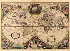
Title:
“Nova Totius Terrarum Orbis Geographica Ac Hydrographica Tabula”
Map Maker:
Hondius/Jansson
Original color. A lavishly ornate double hemispher... (full text available to subscribers)
| Item Detail |
| |
| |
MapMaker: |
Hondius/Jansson
|
|
| |
| |
Subject: |
17th Century World |
|
| |
Period/Size: |
1630 / 14.9" x 21.4" (37.8 x 54.3 cm)
|
|
| |
Color: |
Colored
|
|
| |
Condition: |
Appears to have been rebacked with very thin Japanese paper to reinforce a number of paper splits resulting from oxidization of green pigment. Slight printer's crease to the left of vertical fold at bottom. Otherwise very good condition. (condition help) |
|
| |
Source: |
|
|
| |
References: |
Shirley: Mapping of the World: 336. |
|
| |
|
|
| Sales Information |
| |
| |
Price: |
|
|
| |
| |
Offered by: |
Heritage Map Museum |
|
| |
Catalog: |
Antique Map Auction - September 2000 (255) |
|
| |
Lot/Item #: |
|
|
| |
| |
Date: |
09/2000
|
|
| |
| |
|
Antique Maps - Valuation and Pricing, Descriptions, Resources |
|
Home |
Information |
Search |
Register |
Contact Us |
Site Map
Americana Exchange, Inc. © 1999 - 2024 Americana Exchange, Inc.. All rights reserved.
OldMaps.com, the OldMaps.com logo and
AMPR are service marks or registered service marks of Americana Exchange, Inc..
|