Title:
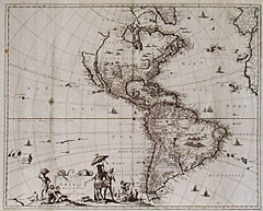
“Novissima et Accuratissima Totius Americae Descriptio”
Map Maker:
Gerrit Lucaszoon van Schagen
Follows Visscher's map of 1658. California is show... (full text available to subscribers)
| Item Detail |
| |
| |
MapMaker: |
Gerrit Lucaszoon van Schagen
|
|
| |
| |
Subject: |
17th Century Americas |
|
| |
Period/Size: |
1671 / 24.5" x 17.0" (62.3 x 43.2 cm)
|
|
| |
Color: |
Black & White
|
|
| |
Condition: |
Several fold splits and interior paper breaks have been repaired. Two filled holes, one in the Atlantic Ocean, another in Brazil with some data loss. A few spots of foxing. Sold w.a.f. (condition help) |
|
| |
Source: |
|
|
| |
References: |
|
|
| |
|
|
| Sales Information |
| |
| |
Price: |
|
|
| |
| |
Offered by: |
Heritage Map Museum |
|
| |
Catalog: |
Antique Map Auction - September 1999 (250) |
|
| |
Lot/Item #: |
|
|
| |
| |
Date: |
09/1999
|
|
| |
| |
|
Antique Maps - Valuation and Pricing, Descriptions, Resources |
|
Home |
Information |
Search |
Register |
Contact Us |
Site Map
Americana Exchange, Inc. © 1999 - 2024 Americana Exchange, Inc.. All rights reserved.
OldMaps.com, the OldMaps.com logo and
AMPR are service marks or registered service marks of Americana Exchange, Inc..
|