| Item Detail |
| |
| |
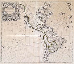
MapMaker: |
John Senex
|
|
| |
| |
Subject: |
18th Century Americas |
|
| |
Period/Size: |
1719 / 22.0" x 19.0" (55.9 x 48.3 cm)
|
|
| |
Color: |
Colored
|
|
| |
Condition: |
Partial outline color. Strong impression. Couple of light foxings. An interior tear near the vertical fold (2 1/2") has been closed and reinforced on verso with old paper. Some faint toning and foxing. (condition help) |
|
| |
Source: |
|
|
| |
References: |
McLaughlin, The Mapping of California as an Island: 193; Tooley: The Mapping of America: p. 130, #81. |
|
| |
|
|
| Sales Information |
| |
| |
Price: |
|
|
| |
| |
Offered by: |
Heritage Map Museum |
|
| |
Catalog: |
Antique Map Auction - September 1998 (248) |
|
| |
Lot/Item #: |
|
|
| |
| |
Date: |
09/1998
|
|
| |
| |
|