Title:
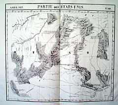
“Partie des Etats Unis”
Map Maker:
Philippe Marie Guillaume Vandermaelen
Shows Lewis and Clark details in this Eastern "Ore... (full text available to subscribers)
| Item Detail |
| |
| |
MapMaker: |
Philippe Marie Guillaume Vandermaelen
|
|
| |
| |
Subject: |
Northwest United States |
|
| |
Period/Size: |
1827 / 18.0" x 20.4" (45.8 x 51.8 cm)
|
|
| |
Color: |
Black & White
|
|
| |
Condition: |
Very slight toning along centerfold. Worm holes on bottom margin do not affect the image. Wide margins. Fine. (condition help) |
|
| |
Source: |
|
|
| |
References: |
|
|
| |
|
|
| Sales Information |
| |
| |
Price: |
|
|
| |
| |
Offered by: |
Heritage Map Museum |
|
| |
Catalog: |
Antique Map Auction - June 2000 (253) |
|
| |
Lot/Item #: |
|
|
| |
| |
Date: |
06/2000
|
|
| |
| |
|
Antique Maps - Valuation and Pricing, Descriptions, Resources |
|
Home |
Information |
Search |
Register |
Contact Us |
Site Map
Americana Exchange, Inc. © 1999 - 2024 Americana Exchange, Inc.. All rights reserved.
OldMaps.com, the OldMaps.com logo and
AMPR are service marks or registered service marks of Americana Exchange, Inc..
|