| Item Detail |
| |
| |
MapMaker: |
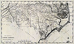
Mathew Carey
|
|
| |
| |
Subject: |
North Carolina |
|
| |
Period/Size: |
1795 / 18.5" x 11.0" (47.0 x 28.0 cm)
|
|
| |
Color: |
Black & White
|
|
| |
Condition: |
One printer's crease runs across the image from top to bottom. Two printer's creases intrude slightly past the neatline. A few extremely faint marks, which are not visually distracting. A very strong engraving in very good condition. (condition help) |
|
| |
Source: |
|
|
| |
References: |
Wheat & Brun, Maps and Charts of America Published Before 1800, #581. |
|
| |
|
|
| Sales Information |
| |
| |
Price: |
|
|
| |
| |
Offered by: |
Heritage Map Museum |
|
| |
Catalog: |
Antique Map Auction - March 1998 (246) |
|
| |
Lot/Item #: |
|
|
| |
| |
Date: |
03/1998
|
|
| |
| |
|