Title:
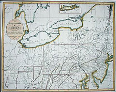
“A Map of the Middle States, of America. Comprehends New York, New Jersey, Pennsylvania, Delaware, and the Territory N.W. of Ohio by J. Russell”
Map Maker:
John Russell
Small inset of Long Island at top. Shows good deta... (full text available to subscribers)
| Item Detail |
| |
| |
MapMaker: |
John Russell
|
|
| |
| |
Subject: |
Mid Atlantic States and Northwest Territory |
|
| |
Period/Size: |
1794 / 14.3" x 18.3" (36.2 x 46.4 cm)
|
|
| |
Color: |
Colored
|
|
| |
Condition: |
Original color. Tight margins on top and left. Folds have been flattened. (condition help) |
|
| |
Source: |
|
|
| |
References: |
|
|
| |
|
|
| Sales Information |
| |
| |
Price: |
|
|
| |
| |
Offered by: |
Heritage Map Museum |
|
| |
Catalog: |
Antique Map Auction - December 2000 (256) |
|
| |
Lot/Item #: |
|
|
| |
| |
Date: |
12/2000
|
|
| |
| |
|
Antique Maps - Valuation and Pricing, Descriptions, Resources |
|
Home |
Information |
Search |
Register |
Contact Us |
Site Map
Americana Exchange, Inc. © 1999 - 2024 Americana Exchange, Inc.. All rights reserved.
OldMaps.com, the OldMaps.com logo and
AMPR are service marks or registered service marks of Americana Exchange, Inc..
|