Title:
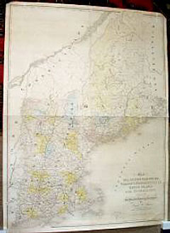
“Map of Maine, New Hampshire, Vermont, Massachusetts, Rhode Island and Connecticut Exhibiting the Post Offices, Post Roads, Canals, Railroads, etc”
Map Maker:
David H. Burr
Four sheets joined on heavy paper. Partial color. ... (full text available to subscribers)
| Item Detail |
| |
| |
MapMaker: |
David H. Burr
|
|
| |
| |
Subject: |
New England |
|
| |
Period/Size: |
1839 / 35.8" x 48.0" (90.8 x 122.0 cm)
|
|
| |
Color: |
Colored
|
|
| |
Condition: |
Very good condition. One paper scuff top right corner, but visually not a problem. (condition help) |
|
| |
Source: |
|
|
| |
References: |
|
|
| |
|
|
| Sales Information |
| |
| |
Price: |
|
|
| |
| |
Offered by: |
Heritage Map Museum |
|
| |
Catalog: |
Antique Map Auction - December 1999 (251) |
|
| |
Lot/Item #: |
|
|
| |
| |
Date: |
12/1999
|
|
| |
| |
|
Antique Maps - Valuation and Pricing, Descriptions, Resources |
|
Home |
Information |
Search |
Register |
Contact Us |
Site Map
Americana Exchange, Inc. © 1999 - 2024 Americana Exchange, Inc.. All rights reserved.
OldMaps.com, the OldMaps.com logo and
AMPR are service marks or registered service marks of Americana Exchange, Inc..
|