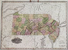
Rister or Sign In to see pricing information


Title:

Map of Pennsylvania and New Jersey

Map Maker:

Henry Schenck Tanner

Map of Pennsylvania and New Jersey

Item Detail
 
  MapMaker:  

Henry Schenck Tanner


  Subject:  Pennsylvania  
  Period/Size:  1823 / 28.0" x 20.5"  (71.2 x 52.1 cm)  
  Color:  Colored  
  Condition:  Folds splits, closed on verso, intrude about 1" past the neat-line at the top and bottom. A pair of brown spots at the top, mostly in the margin, reach just past the border. (condition help)  
  Source:   
  References:   
 
 
Sales Information
 
  Price: 

Please register your email to view records, or sign in with email address to see records


  Offered by:  Heritage Map Museum  
  Catalog:  Antique Map Auction - September 1999 (250)  
  Lot/Item #:   
 
  Date:  09/1999  


Antique Maps - Valuation and Pricing, Descriptions, Resources


Home | Information | Search | Register | Contact Us | Site Map

Americana Exchange, Inc. © 1999 - 2024 Americana Exchange, Inc.. All rights reserved. OldMaps.com, the OldMaps.com logo and
AMPR are service marks or registered service marks of Americana Exchange, Inc..