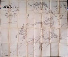
Title:
“Map of the Country Upon the Brazos and Big Wichita Rivers Explored in 1854”
Map Maker:
Randolph Barnes Marcy
Shows the area of 92 to 98 degrees longitude and 3... (full text available to subscribers)
| Item Detail |
| |
| |
MapMaker: |
Randolph Barnes Marcy
|
|
| |
| |
Subject: |
Texas |
|
| |
Period/Size: |
1854 / 25.8" x 31.0" (65.4 x 78.8 cm)
|
|
| |
Color: |
Black & White
|
|
| |
Condition: |
Folding map in fine condition. (condition help) |
|
| |
Source: |
|
|
| |
References: |
|
|
| |
|
|
| Sales Information |
| |
| |
Price: |
|
|
| |
| |
Offered by: |
Heritage Map Museum |
|
| |
Catalog: |
Antique Map Auction - December 2000 (256) |
|
| |
Lot/Item #: |
|
|
| |
| |
Date: |
12/2000
|
|
| |
| |
|
Antique Maps - Valuation and Pricing, Descriptions, Resources |
|
Home |
Information |
Search |
Register |
Contact Us |
Site Map
Americana Exchange, Inc. © 1999 - 2024 Americana Exchange, Inc.. All rights reserved.
OldMaps.com, the OldMaps.com logo and
AMPR are service marks or registered service marks of Americana Exchange, Inc..
|