Title:
“Map of the United States and Canada”
Map Maker:
Roswell Chamberlain Smith [& Co.]
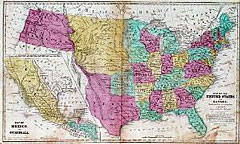
Shows Texas as a Republic with its borders consist... (full text available to subscribers)
| Item Detail |
| |
| |
MapMaker: |
Roswell Chamberlain Smith [& Co.]
|
|
| |
| |
Subject: |
United States |
|
| |
Period/Size: |
1839 / 17.6" x 10.5" (44.8 x 26.7 cm)
|
|
| |
Color: |
Colored
|
|
| |
Condition: |
Strong original color. Moderate foxing and toning with darker stain lower right off of Florida. Minor softness on lower vertical fold next to border and reinforced with archival tape on verso. (condition help) |
|
| |
Source: |
|
|
| |
References: |
|
|
| |
|
|
| Sales Information |
| |
| |
Price: |
|
|
| |
| |
Offered by: |
Heritage Map Museum |
|
| |
Catalog: |
Antique Map Auction - June 1998 (247) |
|
| |
Lot/Item #: |
|
|
| |
| |
Date: |
06/1998
|
|
| |
| |
|
Antique Maps - Valuation and Pricing, Descriptions, Resources |
|
Home |
Information |
Search |
Register |
Contact Us |
Site Map
Americana Exchange, Inc. © 1999 - 2024 Americana Exchange, Inc.. All rights reserved.
OldMaps.com, the OldMaps.com logo and
AMPR are service marks or registered service marks of Americana Exchange, Inc..
|