Title:
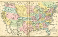
“Map of the United States and Canada. Designed to Accompany Smith's Geography for Schools”
Map Maker:
Roswell Chamberlain Smith [& Co.]
Most of the western lands are shown as large terri... (full text available to subscribers)
| Item Detail |
| |
| |
MapMaker: |
Roswell Chamberlain Smith [& Co.]
|
|
| |
| |
Subject: |
United States |
|
| |
Period/Size: |
1853 / 1857 / 10.5" x 17.7" (26.7 x 44.9 cm)
|
|
| |
Color: |
Colored
|
|
| |
Condition: |
Original color. Random foxing, primarily in margins and blank areas. Bottom corners show wear from use, otherwise very good condition. (condition help) |
|
| |
Source: |
|
|
| |
References: |
|
|
| |
|
|
| Sales Information |
| |
| |
Price: |
|
|
| |
| |
Offered by: |
Heritage Map Museum |
|
| |
Catalog: |
Antique Map Auction - June 2001 (235) |
|
| |
Lot/Item #: |
119 |
|
| |
| |
Date: |
06/2001
|
|
| |
| |
|
Antique Maps - Valuation and Pricing, Descriptions, Resources |
|
Home |
Information |
Search |
Register |
Contact Us |
Site Map
Americana Exchange, Inc. © 1999 - 2024 Americana Exchange, Inc.. All rights reserved.
OldMaps.com, the OldMaps.com logo and
AMPR are service marks or registered service marks of Americana Exchange, Inc..
|