Title:
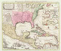
“Mappa Geographica Regionem Mexicanam et Floridam Terrasque Adjacentes, ut et Anteriores Americae Insulas Cursus Itidem et Reditus Navigantium versus Flumen Missisipi et Alias Colonias …”
Map Maker:
Matthaus Seutter
Strong detail and numerous place names. A view of ... (full text available to subscribers)
| Item Detail |
| |
| |
MapMaker: |
Matthaus Seutter
|
|
| |
| |
Subject: |
Gulf of Mexico and Caribbean |
|
| |
Period/Size: |
1740 / 22.5" x 18.6" (57.2 x 47.3 cm)
|
|
| |
Color: |
Colored
|
|
| |
Condition: |
Very good to fine condition. (condition help) |
|
| |
Source: |
|
|
| |
References: |
|
|
| |
|
|
| Sales Information |
| |
| |
Price: |
|
|
| |
| |
Offered by: |
Heritage Map Museum |
|
| |
Catalog: |
16th to 19th Century Rare Map & Book Auction: VIII - June 14, 1997 (8988) |
|
| |
Lot/Item #: |
34 |
|
| |
| |
Date: |
06/1997
|
|
| |
| |
|
Antique Maps - Valuation and Pricing, Descriptions, Resources |
|
Home |
Information |
Search |
Register |
Contact Us |
Site Map
Americana Exchange, Inc. © 1999 - 2024 Americana Exchange, Inc.. All rights reserved.
OldMaps.com, the OldMaps.com logo and
AMPR are service marks or registered service marks of Americana Exchange, Inc..
|