Title:
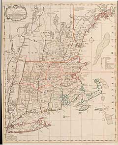
“A Map of the Inhabited Part of New England, Containing the Provinces of Massachusetts Bay and New Hampshire, with the Colonies of Conecticut and Rhode Island, Divided into Counties and Townships”
Map Maker:
Thomas Bowles [Family]
A particularly dynamic moment in the period prior ... (full text available to subscribers)
| Item Detail |
| |
| |
MapMaker: |
Thomas Bowles [Family]
|
|
| |
| |
Subject: |
Northeast |
|
| |
Period/Size: |
1771 / 20.5" x 25.3" (52.1 x 64.2 cm)
|
|
| |
Color: |
Colored
|
|
| |
Condition: |
Some outline color. Some light surface soiling and a couple of light spots., else very good. (condition help) |
|
| |
Source: |
|
|
| |
References: |
|
|
| |
|
|
| Sales Information |
| |
| |
Price: |
|
|
| |
| |
Offered by: |
Heritage Map Museum |
|
| |
Catalog: |
Antique Map Auction - March 1996 (244) |
|
| |
Lot/Item #: |
|
|
| |
| |
Date: |
03/1996
|
|
| |
| |
|
Antique Maps - Valuation and Pricing, Descriptions, Resources |
|
Home |
Information |
Search |
Register |
Contact Us |
Site Map
Americana Exchange, Inc. © 1999 - 2024 Americana Exchange, Inc.. All rights reserved.
OldMaps.com, the OldMaps.com logo and
AMPR are service marks or registered service marks of Americana Exchange, Inc..
|