Title:
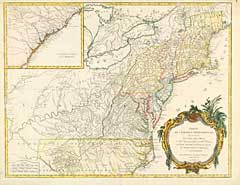
“Partie de l'Amerique Septentrionale, qui Comprend le Cours de l'Ohio, la Nlle. Angleterre, la Nlle. York, le New Jersey, la Pensylvanie, le Maryland la Virginie, la Caroline”
Map Maker:
Robert de Vaugondy [Family]
Inset of Caroline coast. Louisiane reaches to bor... (full text available to subscribers)
| Item Detail |
| |
| |
MapMaker: |
Robert de Vaugondy [Family]
|
|
| |
| |
Subject: |
Northeast |
|
| |
Period/Size: |
1755 / 24.5" x 18.8" (62.3 x 47.7 cm)
|
|
| |
Color: |
Colored
|
|
| |
Condition: |
Outline color. Rich dark impression. Some slight surface soiling, else very good. (condition help) |
|
| |
Source: |
|
|
| |
References: |
|
|
| |
|
|
| Sales Information |
| |
| |
Price: |
|
|
| |
| |
Offered by: |
Heritage Map Museum |
|
| |
Catalog: |
Antique Map Auction - June 1996 (243) |
|
| |
Lot/Item #: |
|
|
| |
| |
Date: |
06/1996
|
|
| |
| |
|
Antique Maps - Valuation and Pricing, Descriptions, Resources |
|
Home |
Information |
Search |
Register |
Contact Us |
Site Map
Americana Exchange, Inc. © 1999 - 2024 Americana Exchange, Inc.. All rights reserved.
OldMaps.com, the OldMaps.com logo and
AMPR are service marks or registered service marks of Americana Exchange, Inc..
|