Title:
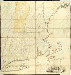
“A Map of the Most Inhabited part of New England containing the Provinces of Massachusetts Bay and New Hampshire with the Colonies of Connecticut and Rhode Island Divided into Counties and Townships”
Map Maker:
Jefferys & Faden
2 insets: "A Plan of Boston Harbor" and "A Plan of... (full text available to subscribers)
| Item Detail |
| |
| |
MapMaker: |
Jefferys & Faden
|
|
| |
| |
Subject: |
Northeast |
|
| |
Period/Size: |
1774 / 39.0" x 41.0" (99.1 x 104.2 cm)
|
|
| |
Color: |
Colored
|
|
| |
Condition: |
Outline and some wash color. Crisp impression with only some minor finger smudges. No tears on linen. (condition help) |
|
| |
Source: |
|
|
| |
References: |
|
|
| |
|
|
| Sales Information |
| |
| |
Price: |
|
|
| |
| |
Offered by: |
Heritage Map Museum |
|
| |
Catalog: |
Antique Map Auction - December 1999 (251) |
|
| |
Lot/Item #: |
|
|
| |
| |
Date: |
12/1999
|
|
| |
| |
|
Antique Maps - Valuation and Pricing, Descriptions, Resources |
|
Home |
Information |
Search |
Register |
Contact Us |
Site Map
Americana Exchange, Inc. © 1999 - 2024 Americana Exchange, Inc.. All rights reserved.
OldMaps.com, the OldMaps.com logo and
AMPR are service marks or registered service marks of Americana Exchange, Inc..
|