| Item Detail |
| |
| |
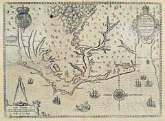
MapMaker: |
Theodore de Bry
|
|
| |
| |
Subject: |
Mid-Atlantic United States. Virginia |
|
| |
Period/Size: |
1628 / 14.4" x 12.0" (36.6 x 30.5 cm)
|
|
| |
Color: |
Black & White
|
|
| |
Condition: |
Overall even light age tone. Some very light foxing in margins, else very good. (condition help) |
|
| |
Source: |
|
|
| |
References: |
Verner, Smith's Virginia…, Derivative #3; Map Collectors' Circle, p. 31; Tooley, The Mapping of America, p.163, Pl. # 71. |
|
| |
|
|
| Sales Information |
| |
| |
Price: |
|
|
| |
| |
Offered by: |
Heritage Map Museum |
|
| |
Catalog: |
Antique Map Auction - June 1996 (243) |
|
| |
Lot/Item #: |
|
|
| |
| |
Date: |
06/1996
|
|
| |
| |
|