Title:
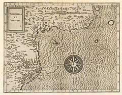
“Norumbega et Virginia”
Map Maker:
Cornelis Wytfliet
Depicts coastline Northward from Virginia to Cape... (full text available to subscribers)
| Item Detail |
| |
| |
MapMaker: |
Cornelis Wytfliet
|
|
| |
| |
Subject: |
Eastern United States |
|
| |
Period/Size: |
1611 / 11.5" x 9.0" (29.3 x 22.9 cm)
|
|
| |
Color: |
Colored
|
|
| |
Condition: |
Fine engraving with margins. (condition help) |
|
| |
Source: |
|
|
| |
References: |
Goss, Map # 21. Swartz and Ehrenberg, p.80. Washington College's On The Map. P.6. Cummings: 19. |
|
| |
|
|
| Sales Information |
| |
| |
Price: |
|
|
| |
| |
Offered by: |
Heritage Map Museum |
|
| |
Catalog: |
Antique Map Auction - June 1996 (243) |
|
| |
Lot/Item #: |
|
|
| |
| |
Date: |
06/1996
|
|
| |
| |
|
Antique Maps - Valuation and Pricing, Descriptions, Resources |
|
Home |
Information |
Search |
Register |
Contact Us |
Site Map
Americana Exchange, Inc. © 1999 - 2024 Americana Exchange, Inc.. All rights reserved.
OldMaps.com, the OldMaps.com logo and
AMPR are service marks or registered service marks of Americana Exchange, Inc..
|