Rister or Sign In to see pricing information


Title:

Tabula I Europae

Map Maker:

Ptolemy/Fries

Tabula I Europae

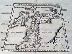
A reduced version of map published by Martin Wald... (full text available to subscribers)
Item Detail
 
  MapMaker:  

Ptolemy/Fries


  Subject:  Britain, British Isles  
  Period/Size:  1522 - 1535 / 16.0" x 11.6"  (40.7 x 29.6 cm)  
  Color:  Black & White  
  Condition:  Some very faint occasional foxing, and a few stitch holes along the vertical centerfold with very minor loss. Overall very good condition. (condition help)  
  Source:   
  References:   
 
 
Sales Information
 
  Price: 

Please register your email to view records, or sign in with email address to see records


  Offered by:  Heritage Map Museum  
  Catalog:  Antique Map Auction - September 1998 (248)  
  Lot/Item #:   
 
  Date:  09/1998  


Antique Maps - Valuation and Pricing, Descriptions, Resources


Home | Information | Search | Register | Contact Us | Site Map

Americana Exchange, Inc. © 1999 - 2024 Americana Exchange, Inc.. All rights reserved. OldMaps.com, the OldMaps.com logo and
AMPR are service marks or registered service marks of Americana Exchange, Inc..