Title:
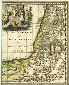
“Totius Terrae Sanctae Delineatio”
Map Maker:
Philipp Cluver
A view of the Holy Land divided into tribes. Attr... (full text available to subscribers)
| Item Detail |
| |
| |
MapMaker: |
Philipp Cluver
|
|
| |
| |
Subject: |
Holy Land |
|
| |
Period/Size: |
1697 / 8.5" x 10.5" (21.6 x 26.7 cm)
|
|
| |
Color: |
Colored
|
|
| |
Condition: |
Newer color. Folds as issued. Very good condition. (condition help) |
|
| |
Source: |
|
|
| |
References: |
|
|
| |
|
|
| Sales Information |
| |
| |
Price: |
|
|
| |
| |
Offered by: |
Heritage Map Museum |
|
| |
Catalog: |
Antique Map Auction - June 2001 (235) |
|
| |
Lot/Item #: |
305 |
|
| |
| |
Date: |
06/2001
|
|
| |
| |
|
Antique Maps - Valuation and Pricing, Descriptions, Resources |
|
Home |
Information |
Search |
Register |
Contact Us |
Site Map
Americana Exchange, Inc. © 1999 - 2024 Americana Exchange, Inc.. All rights reserved.
OldMaps.com, the OldMaps.com logo and
AMPR are service marks or registered service marks of Americana Exchange, Inc..
|