Title:
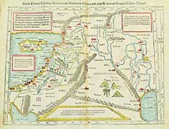
“Syria Cypern Palestina Mesopotamia Babylonia Chaldea und zwey Arabia mit Bergen Wassern und Statten”
Map Maker:
Sebastian Munster
A Ptolemaic view of the Middle East from the Nile ... (full text available to subscribers)
| Item Detail |
| |
| |
MapMaker: |
Sebastian Munster
|
|
| |
| |
Subject: |
Holy Land |
|
| |
Period/Size: |
1572 / 13.1" x 9.8" (33.4 x 24.8 cm)
|
|
| |
Color: |
Colored
|
|
| |
Condition: |
New color. Very light age toning along the center fold. A few pin holes along the centerfold which have been expertly repaired. (condition help) |
|
| |
Source: |
|
|
| |
References: |
Laor, Maps of the Holy Land: #525. |
|
| |
|
|
| Sales Information |
| |
| |
Price: |
|
|
| |
| |
Offered by: |
Heritage Map Museum |
|
| |
Catalog: |
16th to 19th Century Rare Map & Book Auction: VIII - June 14, 1997 (8988) |
|
| |
Lot/Item #: |
124 |
|
| |
| |
Date: |
06/1997
|
|
| |
| |
|
Antique Maps - Valuation and Pricing, Descriptions, Resources |
|
Home |
Information |
Search |
Register |
Contact Us |
Site Map
Americana Exchange, Inc. © 1999 - 2024 Americana Exchange, Inc.. All rights reserved.
OldMaps.com, the OldMaps.com logo and
AMPR are service marks or registered service marks of Americana Exchange, Inc..
|