Title:
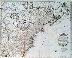
“Map of the United States in North America: with the British, French, and Spanish Dominions adjoining, according to the Treaty of 1783”
Map Maker:
Thomas Kitchin
Very nice detail. This early map of the United Sta... (full text available to subscribers)
| Item Detail |
| |
| |
MapMaker: |
Thomas Kitchin
|
|
| |
| |
Subject: |
United States |
|
| |
Period/Size: |
1783 / 19.9" x 16.0" (50.5 x 40.7 cm)
|
|
| |
Color: |
Black & White
|
|
| |
Condition: |
Folds, as issued. A couple of faint spots of foxing. Overall very good condition. (condition help) |
|
| |
Source: |
|
|
| |
References: |
|
|
| |
|
|
| Sales Information |
| |
| |
Price: |
|
|
| |
| |
Offered by: |
Heritage Map Museum |
|
| |
Catalog: |
Antique Map Auction - June 1998 (247) |
|
| |
Lot/Item #: |
|
|
| |
| |
Date: |
06/1998
|
|
| |
| |
|
Antique Maps - Valuation and Pricing, Descriptions, Resources |
|
Home |
Information |
Search |
Register |
Contact Us |
Site Map
Americana Exchange, Inc. © 1999 - 2024 Americana Exchange, Inc.. All rights reserved.
OldMaps.com, the OldMaps.com logo and
AMPR are service marks or registered service marks of Americana Exchange, Inc..
|