Title:
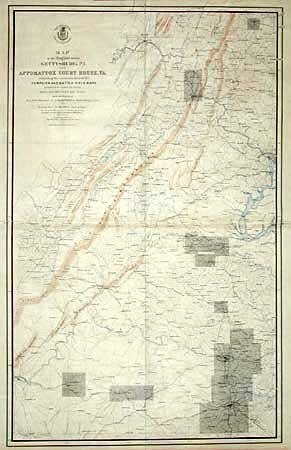
“Map of the Region between Gettysburg, PA. and Appomattox Court House, VA. Exhibiting the connection between Campaign and Battle-Field Maps prepared by Authority of the Hon. Secretary of War.”
Map Maker:
U.S. War Department
This large and important is the index map made to... (full text available to subscribers)
| Item Detail |
| |
| |
MapMaker: |
U.S. War Department
|
|
| |
| |
Subject: |
Pennsylvania |
|
| |
Period/Size: |
1869 / 43.3" x 27.0" (110.0 x 68.6 cm)
|
|
| |
Color: |
Colored
|
|
| |
Condition: |
(B) Printed on four sheets and joined on linen. Marginal staining in top margin, lightly toned from glue, and a few small areas of roughness at joins, but remarkable condition for a map of this size. (condition help) |
|
| |
Source: |
|
|
| |
References: |
Stephenson (CW) #518 & S196; Phillips (A) #3688. |
|
| |
|
|
| Sales Information |
| |
| |
Price: |
|
|
| |
| |
Offered by: |
Old World Auctions |
|
| |
Catalog: |
Auction No. 98 - Antique Maps, Charts, Atlases & Globes (303) |
|
| |
Lot/Item #: |
199 |
|
| |
| |
Date: |
03/2002
|
|
| |
| |
|
Antique Maps - Valuation and Pricing, Descriptions, Resources |
|
Home |
Information |
Search |
Register |
Contact Us |
Site Map
Americana Exchange, Inc. © 1999 - 2024 Americana Exchange, Inc.. All rights reserved.
OldMaps.com, the OldMaps.com logo and
AMPR are service marks or registered service marks of Americana Exchange, Inc..
|