Title:
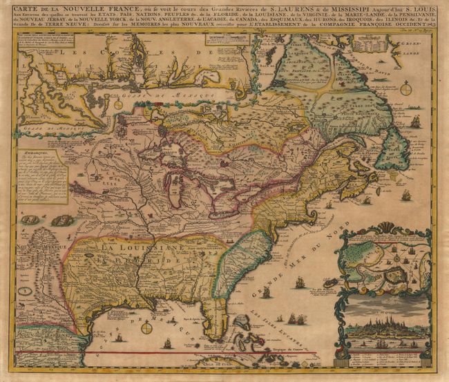
“Carte de la Nouvelle France, ou se voit le cours des Grandes Rivieres de S. Laurens & de Mississipi Aujour d'hui S. Louis, Aux Environs des-quelles se trouvent les Etats, Pais, Nations, Peuples &c.”
Map Maker:
Henry Abraham Chatelain
This is the second state of Chatelain's reduced ve... (full text available to subscribers)
| Item Detail |
| |
| |
MapMaker: |
Henry Abraham Chatelain
|
|
| |
| |
Subject: |
Colonial North America |
|
| |
Period/Size: |
1732 / 16.5" x 19.1" (42.0 x 48.6 cm)
|
|
| |
Color: |
Colored
|
|
| |
Condition: |
(A) Evenly toned with superb original color. (condition help) |
|
| |
Source: |
Atlas Historique |
|
| |
References: |
Verner and Stuart-Stubbs #11, Kershaw #333. |
|
| |
|
|
| Sales Information |
| |
| |
Price: |
|
|
| |
| |
Offered by: |
Old World Auctions |
|
| |
Catalog: |
Auction No. 98 - Antique Maps, Charts, Atlases & Globes (303) |
|
| |
Lot/Item #: |
086 |
|
| |
| |
Date: |
03/2002
|
|
| |
| |
|
Antique Maps - Valuation and Pricing, Descriptions, Resources |
|
Home |
Information |
Search |
Register |
Contact Us |
Site Map
Americana Exchange, Inc. © 1999 - 2024 Americana Exchange, Inc.. All rights reserved.
OldMaps.com, the OldMaps.com logo and
AMPR are service marks or registered service marks of Americana Exchange, Inc..
|