| Item Detail |
| |
| |
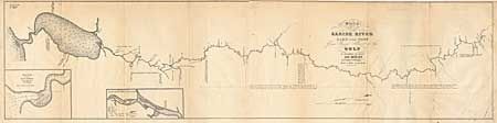
MapMaker: |
J.H. Eaton
|
|
| |
| |
Subject: |
Texas Boundary |
|
| |
Period/Size: |
1837 / 8.5" x 34.0" (21.6 x 86.4 cm)
|
|
| |
Color: |
Black & White
|
|
| |
Condition: |
(B) Close top margin and backed with Japanese tissue and paper added at binding corner. A little surface soiling. (condition help) |
|
| |
Source: |
HR Doc. 365, 25th Cong., 2nd Session |
|
| |
References: |
Clausen & Friis #243; Koepp #I-34-1-4. |
|
| |
|
|
| Sales Information |
| |
| |
Price: |
|
|
| |
| |
Offered by: |
Old World Auctions |
|
| |
Catalog: |
Auction No. 98 - Antique Maps, Charts, Atlases & Globes (303) |
|
| |
Lot/Item #: |
204 |
|
| |
| |
Date: |
03/2002
|
|
| |
| |
|