Title:
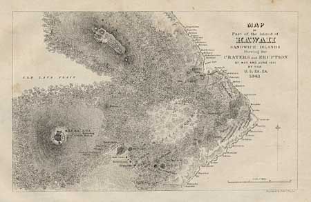
“Map of Part of the Island of Hawaii, Sandwich Islands Shewing the Craters and Eruption of May and June 1841”
Map Maker:
Charles Wilkes
Covers the area of the 'Big Island' from Hilo to M... (full text available to subscribers)
| Item Detail |
| |
| |
MapMaker: |
Charles Wilkes
|
|
| |
| |
Subject: |
Hawaii |
|
| |
Period/Size: |
1845 / 4.5" x 7.1" (11.5 x 18.1 cm)
|
|
| |
Color: |
Black & White
|
|
| |
Condition: |
(B) Full margins and good impression, but with a little foxing. (condition help) |
|
| |
Source: |
Narrative of the United States Exploring Expedition, Vol. 5. |
|
| |
References: |
|
|
| |
|
|
| Sales Information |
| |
| |
Price: |
|
|
| |
| |
Offered by: |
Old World Auctions |
|
| |
Catalog: |
Auction No. 98 - Antique Maps, Charts, Atlases & Globes (303) |
|
| |
Lot/Item #: |
160 |
|
| |
| |
Date: |
03/2002
|
|
| |
| |
|
Antique Maps - Valuation and Pricing, Descriptions, Resources |
|
Home |
Information |
Search |
Register |
Contact Us |
Site Map
Americana Exchange, Inc. © 1999 - 2024 Americana Exchange, Inc.. All rights reserved.
OldMaps.com, the OldMaps.com logo and
AMPR are service marks or registered service marks of Americana Exchange, Inc..
|