Title:
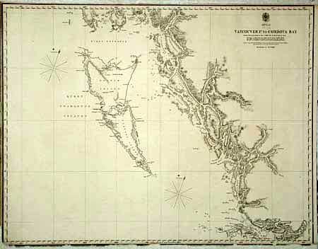
“Vancouver P. to Cordova Bay From a Russian Chart of 1849 - corrected by Mr. Inskip in 1855”
Map Maker:
British Government
Nice coastal chart of the region. The chart inclu... (full text available to subscribers)
| Item Detail |
| |
| |
MapMaker: |
British Government
|
|
| |
| |
Subject: |
Canada |
|
| |
Period/Size: |
1860 / 19.0" x 24.5" (48.3 x 62.3 cm)
|
|
| |
Color: |
Black & White
|
|
| |
Condition: |
(C) Very clean but with badly chipped bottom neatline with paper replacement to extend margins. Backed with tissue. (condition help) |
|
| |
Source: |
British Hydrographic Office |
|
| |
References: |
|
|
| |
|
|
| Sales Information |
| |
| |
Price: |
|
|
| |
| |
Offered by: |
Old World Auctions |
|
| |
Catalog: |
Auction No. 98 - Antique Maps, Charts, Atlases & Globes (303) |
|
| |
Lot/Item #: |
109 |
|
| |
| |
Date: |
03/2002
|
|
| |
| |
|
Antique Maps - Valuation and Pricing, Descriptions, Resources |
|
Home |
Information |
Search |
Register |
Contact Us |
Site Map
Americana Exchange, Inc. © 1999 - 2024 Americana Exchange, Inc.. All rights reserved.
OldMaps.com, the OldMaps.com logo and
AMPR are service marks or registered service marks of Americana Exchange, Inc..
|