Rister or Sign In to see pricing information


Title:

Topographical map of the road from Forth Smith, Arks. To Santa Fe, N.M. and from Dona Ana N.M. to Fort Smith

Map Maker:

U.S. Army

Topographical map of the road from Forth Smith, Arks. To Santa Fe, N.M. and from Dona Ana N.M. to Fort Smith

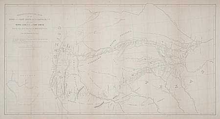
Made by order of Bvt. Brig. Gen. M. Arbuckle, by C... (full text available to subscribers)
Item Detail
 
  MapMaker:  

U.S. Army


  Subject:  United States - Southwestern  
  Period/Size:  1852 / 14.7" x 28.0"  (37.4 x 71.2 cm)  
  Color:  Black & White  
  Condition:  (B) Good impression, but strongly toned along folds. Backed with Japanese tissue. (condition help)  
  Source:  HR Ex Doc. 45, 31st Cong., 1st Session  
  References:  Koep CIS #577; Wheat (TMW) 681.  
 
 
Sales Information
 
  Price: 

Please register your email to view records, or sign in with email address to see records


  Offered by:  Old World Auctions  
  Catalog:  Auction No. 98 - Antique Maps, Charts, Atlases & Globes (303)  
  Lot/Item #:  132  
 
  Date:  03/2002  


Antique Maps - Valuation and Pricing, Descriptions, Resources


Home | Information | Search | Register | Contact Us | Site Map

Americana Exchange, Inc. © 1999 - 2024 Americana Exchange, Inc.. All rights reserved. OldMaps.com, the OldMaps.com logo and
AMPR are service marks or registered service marks of Americana Exchange, Inc..