Rister or Sign In to see pricing information


Title:

That Part of Disturnell's Treaty Map in the Vicinity of the Rio Grande and Southern Boundary of New Mexico as referred to by U.S. Surveyor…

Map Maker:

U.S. Government

That Part of Disturnell's Treaty Map in the Vicinity of the Rio Grande and Southern Boundary of New Mexico as referred to by U.S. Surveyor…

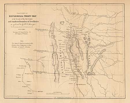
Map covers an area from the Arkansas River south t... (full text available to subscribers)
Item Detail
 
  MapMaker:  

U.S. Government


  Subject:  New Mexico  
  Period/Size:  1851 / 8.7" x 11.0"  (22.1 x 28.0 cm)  
  Color:  Black & White  
  Condition:  (B) Backed with Japanese tissue. Lightly toned, else very good. (condition help)  
  Source:  Senate Ex Doc. 19, 32rd Cong., 1st Session  
  References:  Koepp CIS 626, map #4; Wheat (TMW) 720.  
 
 
Sales Information
 
  Price: 

Please register your email to view records, or sign in with email address to see records


  Offered by:  Old World Auctions  
  Catalog:  Auction No. 98 - Antique Maps, Charts, Atlases & Globes (303)  
  Lot/Item #:  186  
 
  Date:  03/2002  


Antique Maps - Valuation and Pricing, Descriptions, Resources


Home | Information | Search | Register | Contact Us | Site Map

Americana Exchange, Inc. © 1999 - 2024 Americana Exchange, Inc.. All rights reserved. OldMaps.com, the OldMaps.com logo and
AMPR are service marks or registered service marks of Americana Exchange, Inc..