Title:
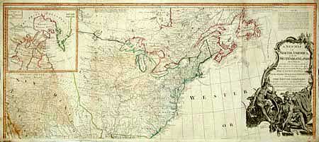
“A New Map of North America with the West India Islands divided according to the Preliminary Articles of Peace, Signed at Versailles, 20 Jan. 1783 wherein are particularly Distinguished The United States and the several Provinces, Governments &c…”
Map Maker:
Laurie & Whittle
Fabulous British wall map on two joined sheets. T... (full text available to subscribers)
| Item Detail |
| |
| |
MapMaker: |
Laurie & Whittle
|
|
| |
| |
Subject: |
North America |
|
| |
Period/Size: |
1794 / 46.0" x 20.0" (116.9 x 50.8 cm)
|
|
| |
Color: |
Colored
|
|
| |
Condition: |
(B) Two areas of loss at sides about 2"x1" entering border and just into map, with new hand laid paper attached from back with facsimile. (condition help) |
|
| |
Source: |
General Atlas |
|
| |
References: |
Stevens & Tree 49. |
|
| |
|
|
| Sales Information |
| |
| |
Price: |
|
|
| |
| |
Offered by: |
Old World Auctions |
|
| |
Catalog: |
Auction No. 98 - Antique Maps, Charts, Atlases & Globes (303) |
|
| |
Lot/Item #: |
076 |
|
| |
| |
Date: |
03/2002
|
|
| |
| |
|
Antique Maps - Valuation and Pricing, Descriptions, Resources |
|
Home |
Information |
Search |
Register |
Contact Us |
Site Map
Americana Exchange, Inc. © 1999 - 2024 Americana Exchange, Inc.. All rights reserved.
OldMaps.com, the OldMaps.com logo and
AMPR are service marks or registered service marks of Americana Exchange, Inc..
|