Title:
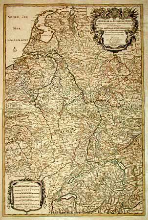
“Le Cours de La Riviere du Rhein depuis sa Sources jusques a son Emboucheure ou sont distingues Tous les Etats et Souverainetes…”
Map Maker:
Sanson/Jaillot
Huge, handsome map that details the course of the ... (full text available to subscribers)
| Item Detail |
| |
| |
MapMaker: |
Sanson/Jaillot
|
|
| |
| |
Subject: |
Central Europe |
|
| |
Period/Size: |
1692 / 33.5" x 22.5" (85.1 x 57.2 cm)
|
|
| |
Color: |
Colored
|
|
| |
Condition: |
(B) Mounted on linen. Beautiful impression that is crisp and black. Scattered foxing/toning throughout. (condition help) |
|
| |
Source: |
Atlantic Neptune Atlas |
|
| |
References: |
Phillips (A) 514. |
|
| |
|
|
| Sales Information |
| |
| |
Price: |
|
|
| |
| |
Offered by: |
Old World Auctions |
|
| |
Catalog: |
Auction No. 98 - Antique Maps, Charts, Atlases & Globes (303) |
|
| |
Lot/Item #: |
267 |
|
| |
| |
Date: |
03/2002
|
|
| |
| |
|
Antique Maps - Valuation and Pricing, Descriptions, Resources |
|
Home |
Information |
Search |
Register |
Contact Us |
Site Map
Americana Exchange, Inc. © 1999 - 2024 Americana Exchange, Inc.. All rights reserved.
OldMaps.com, the OldMaps.com logo and
AMPR are service marks or registered service marks of Americana Exchange, Inc..
|