Title:
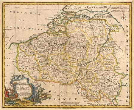
“A New & Correct Map of the Netherlands, or Low Countries, Drawn from the best Authorities and most approved Modern Maps, the whole being regulated by Astron.l Observations”
Map Maker:
Emanuel Bowen
Well engraved and detailed map with a decorative c... (full text available to subscribers)
| Item Detail |
| |
| |
MapMaker: |
Emanuel Bowen
|
|
| |
| |
Subject: |
Belgium and Netherlands |
|
| |
Period/Size: |
1750 / 13.5" x 16.5" (34.3 x 42.0 cm)
|
|
| |
Color: |
Colored
|
|
| |
Condition: |
(B) On a full sheet of hand laid paper with large fleur-de-lys watermark. Toned along centerfold, else very good. (condition help) |
|
| |
Source: |
Rapkin's History of England |
|
| |
References: |
|
|
| |
|
|
| Sales Information |
| |
| |
Price: |
|
|
| |
| |
Offered by: |
Old World Auctions |
|
| |
Catalog: |
Auction No. 98 - Antique Maps, Charts, Atlases & Globes (303) |
|
| |
Lot/Item #: |
294 |
|
| |
| |
Date: |
03/2002
|
|
| |
| |
|
Antique Maps - Valuation and Pricing, Descriptions, Resources |
|
Home |
Information |
Search |
Register |
Contact Us |
Site Map
Americana Exchange, Inc. © 1999 - 2024 Americana Exchange, Inc.. All rights reserved.
OldMaps.com, the OldMaps.com logo and
AMPR are service marks or registered service marks of Americana Exchange, Inc..
|