Rister or Sign In to see pricing information


Title:

Extract of Military Map of N.E. Virginia Showing Forts and Roads

Map Maker:

U.S. War Department

Extract of Military Map of N.E. Virginia Showing Forts and Roads

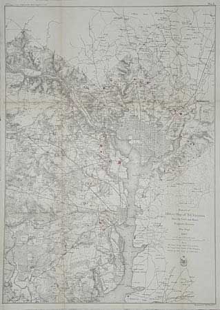
Shows District of Columbia and street grids for Wa... (full text available to subscribers)
Item Detail
 
  MapMaker:  

U.S. War Department


  Subject:  Virginia  
  Period/Size:  1865 / 23.7" x 17.0"  (60.2 x 43.2 cm)  
  Color:  Colored  
  Condition:  (A) Remargined to compensate for binder's trim and backed with Japanese tissue. Minor repairs. Toned at some folds, still very good for this map. (condition help)  
  Source:  39th Cong., 1st Session. Report of the Chief Engineer  
  References:  Stephenson (CW) variant of 685-7.  
 
 
Sales Information
 
  Price: 

Please register your email to view records, or sign in with email address to see records


  Offered by:  Old World Auctions  
  Catalog:  Auction No. 98 - Antique Maps, Charts, Atlases & Globes (303)  
  Lot/Item #:  210  
 
  Date:  03/2002  


Antique Maps - Valuation and Pricing, Descriptions, Resources


Home | Information | Search | Register | Contact Us | Site Map

Americana Exchange, Inc. © 1999 - 2024 Americana Exchange, Inc.. All rights reserved. OldMaps.com, the OldMaps.com logo and
AMPR are service marks or registered service marks of Americana Exchange, Inc..