Title:
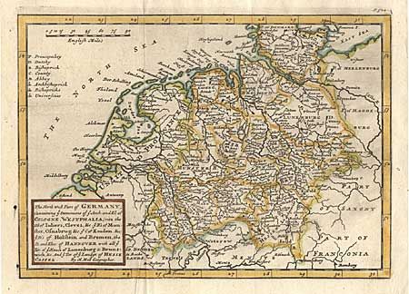
“The North west Part of Germany; Containing ye Dominions of ye Arch: and El; of Cologne, Westphalia, (vits the D's of Juliers, Cleves, &c. ye B's of Munster, Osnabrug &c. C. of Emden &c.) ye D's of Holstein and Bremen, the D. and Elec. Of Hannover…”
Map Maker:
Herman Moll
A well engraved sheet that extends to show the Uni... (full text available to subscribers)
| Item Detail |
| |
| |
MapMaker: |
Herman Moll
|
|
| |
| |
Subject: |
Germany |
|
| |
Period/Size: |
1730 / 7.0" x 9.7" (17.8 x 24.7 cm)
|
|
| |
Color: |
Colored
|
|
| |
Condition: |
(A) Good color and impression. A short printer's crease enters border. (condition help) |
|
| |
Source: |
|
|
| |
References: |
|
|
| |
|
|
| Sales Information |
| |
| |
Price: |
|
|
| |
| |
Offered by: |
Old World Auctions |
|
| |
Catalog: |
Auction No. 98 - Antique Maps, Charts, Atlases & Globes (303) |
|
| |
Lot/Item #: |
311 |
|
| |
| |
Date: |
03/2002
|
|
| |
| |
|
Antique Maps - Valuation and Pricing, Descriptions, Resources |
|
Home |
Information |
Search |
Register |
Contact Us |
Site Map
Americana Exchange, Inc. © 1999 - 2024 Americana Exchange, Inc.. All rights reserved.
OldMaps.com, the OldMaps.com logo and
AMPR are service marks or registered service marks of Americana Exchange, Inc..
|