Title:
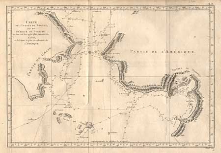
“Carte de l' Entree de Norton, et du Detroit de Bhering ou l' on voit le Cap le plus Oriental de l' Asie, et la Pointe la plus Occidentale de l' Amerique”
Map Maker:
Robert Benard
Detailed copper engraved map showing sections of t... (full text available to subscribers)
| Item Detail |
| |
| |
MapMaker: |
Robert Benard
|
|
| |
| |
Subject: |
North Pacific - Alaska |
|
| |
Period/Size: |
1790 / 10.5" x 15.2" (26.7 x 38.6 cm)
|
|
| |
Color: |
Black & White
|
|
| |
Condition: |
(B) A couple of worm holes and a small puncture in unengraved area of the map. (condition help) |
|
| |
Source: |
Captain Cooks' Voyages (French Edition) |
|
| |
References: |
|
|
| |
|
|
| Sales Information |
| |
| |
Price: |
|
|
| |
| |
Offered by: |
Old World Auctions |
|
| |
Catalog: |
Auction No. 99 - Antique Maps, Charts, Atlases & Globes (304) |
|
| |
Lot/Item #: |
502 |
|
| |
| |
Date: |
06/2002
|
|
| |
| |
|
Antique Maps - Valuation and Pricing, Descriptions, Resources |
|
Home |
Information |
Search |
Register |
Contact Us |
Site Map
Americana Exchange, Inc. © 1999 - 2024 Americana Exchange, Inc.. All rights reserved.
OldMaps.com, the OldMaps.com logo and
AMPR are service marks or registered service marks of Americana Exchange, Inc..
|