Title:
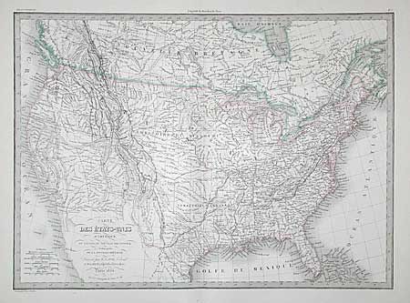
“Carte Des Etats-Unis d' Amerique, du Canada, du Nouveau Brunswick et d' une partie De La nouvelle Bretagne”
Map Maker:
Lapie [Family]
A great mid-nineteenth century map issued shortly ... (full text available to subscribers)
| Item Detail |
| |
| |
MapMaker: |
Lapie [Family]
|
|
| |
| |
Subject: |
Canada & United States |
|
| |
Period/Size: |
1854 / 15.6" x 21.5" (39.7 x 54.7 cm)
|
|
| |
Color: |
Colored
|
|
| |
Condition: |
(B) Some archival tape repairs in wide margins. (condition help) |
|
| |
Source: |
Atlas Universel de Geographie Ancienne et Moderne |
|
| |
References: |
|
|
| |
|
|
| Sales Information |
| |
| |
Price: |
|
|
| |
| |
Offered by: |
Old World Auctions |
|
| |
Catalog: |
Auction No. 99 - Antique Maps, Charts, Atlases & Globes (304) |
|
| |
Lot/Item #: |
142 |
|
| |
| |
Date: |
06/2002
|
|
| |
| |
|
Antique Maps - Valuation and Pricing, Descriptions, Resources |
|
Home |
Information |
Search |
Register |
Contact Us |
Site Map
Americana Exchange, Inc. © 1999 - 2024 Americana Exchange, Inc.. All rights reserved.
OldMaps.com, the OldMaps.com logo and
AMPR are service marks or registered service marks of Americana Exchange, Inc..
|