Title:
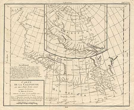
“Carte de la Californie et des Pays Nord Ouest separes de L' Asie par le Detroit d' Anian”
Map Maker:
Gilles Robert de Vaugondy
Two maps, one inset into the other. The inset map... (full text available to subscribers)
| Item Detail |
| |
| |
MapMaker: |
Gilles Robert de Vaugondy
|
|
| |
| |
Subject: |
Colonial West |
|
| |
Period/Size: |
1772 / 11.5" x 14.0" (29.3 x 35.6 cm)
|
|
| |
Color: |
Black & White
|
|
| |
Condition: |
(B) Light impression on thinner paper else very good. (condition help) |
|
| |
Source: |
Diderot's Encyclopaedie |
|
| |
References: |
Wheat (TMW) #159; Wagner (NW) #632; and Pedley #473. |
|
| |
|
|
| Sales Information |
| |
| |
Price: |
|
|
| |
| |
Offered by: |
Old World Auctions |
|
| |
Catalog: |
Auction No. 99 - Antique Maps, Charts, Atlases & Globes (304) |
|
| |
Lot/Item #: |
134 |
|
| |
| |
Date: |
06/2002
|
|
| |
| |
|
Antique Maps - Valuation and Pricing, Descriptions, Resources |
|
Home |
Information |
Search |
Register |
Contact Us |
Site Map
Americana Exchange, Inc. © 1999 - 2024 Americana Exchange, Inc.. All rights reserved.
OldMaps.com, the OldMaps.com logo and
AMPR are service marks or registered service marks of Americana Exchange, Inc..
|