Title:
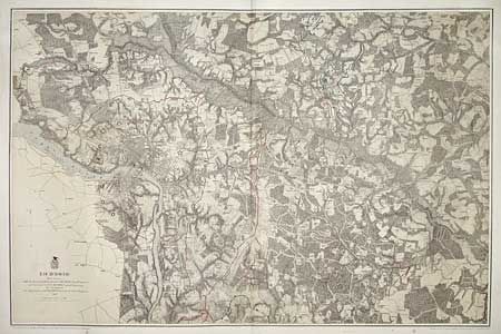
“Richmond From Surveys under the direction of Bvt. Brig. Gen. N. Michler, Maj. Of Engineers and Bvt. Lieut. Col. P.S. Michie, Capt. Of Engineers. By Command of Bvt. Maj. Gen. A.A. Humphries, Brig. Gen. & Chief of Engineers”
Map Maker:
U.S. War Department
Very detailed Civil War map of the vicinity... (full text available to subscribers)
| Item Detail |
| |
| |
MapMaker: |
U.S. War Department
|
|
| |
| |
Subject: |
Virginia |
|
| |
Period/Size: |
1867 / 21.6" x 33.1" (54.9 x 84.1 cm)
|
|
| |
Color: |
Colored
|
|
| |
Condition: |
(A) A couple of insignificant spots in blank area near title. (condition help) |
|
| |
Source: |
|
|
| |
References: |
Phillips [A] Vol. 3 #3688. |
|
| |
|
|
| Sales Information |
| |
| |
Price: |
|
|
| |
| |
Offered by: |
Old World Auctions |
|
| |
Catalog: |
Auction No. 99 - Antique Maps, Charts, Atlases & Globes (304) |
|
| |
Lot/Item #: |
251 |
|
| |
| |
Date: |
06/2002
|
|
| |
| |
|
Antique Maps - Valuation and Pricing, Descriptions, Resources |
|
Home |
Information |
Search |
Register |
Contact Us |
Site Map
Americana Exchange, Inc. © 1999 - 2024 Americana Exchange, Inc.. All rights reserved.
OldMaps.com, the OldMaps.com logo and
AMPR are service marks or registered service marks of Americana Exchange, Inc..
|