Title:
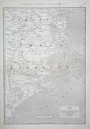
“Map of the Pamlico and Albemarle Sounds, embracing portions of Virginia and North Carolina, with their strategic points and railway connections”
Map Maker:
George Woolworth Colton
Large Civil War map of the coastal region f... (full text available to subscribers)
| Item Detail |
| |
| |
MapMaker: |
George Woolworth Colton
|
|
| |
| |
Subject: |
North Carolina |
|
| |
Period/Size: |
1861-2 / 20.0" x 14.0" (50.8 x 35.6 cm)
|
|
| |
Color: |
Black & White
|
|
| |
Condition: |
(A) Some minor stains in margins. (condition help) |
|
| |
Source: |
Leslie's Pictorial History of the War of 1861 |
|
| |
References: |
|
|
| |
|
|
| Sales Information |
| |
| |
Price: |
|
|
| |
| |
Offered by: |
Old World Auctions |
|
| |
Catalog: |
Auction No. 99 - Antique Maps, Charts, Atlases & Globes (304) |
|
| |
Lot/Item #: |
229 |
|
| |
| |
Date: |
06/2002
|
|
| |
| |
|
Antique Maps - Valuation and Pricing, Descriptions, Resources |
|
Home |
Information |
Search |
Register |
Contact Us |
Site Map
Americana Exchange, Inc. © 1999 - 2024 Americana Exchange, Inc.. All rights reserved.
OldMaps.com, the OldMaps.com logo and
AMPR are service marks or registered service marks of Americana Exchange, Inc..
|