Rister or Sign In to see pricing information


Title:

A Plan of New York Island with part of Long Island, Staten Island & East New Jersey, with a particular Description of the Engagement on the Woody Heights of Long Island … on the 27th of August 1776

Map Maker:

William Faden

A Plan of New York Island with part of Long Island, Staten Island & East New Jersey, with a particular Description of the Engagement on the Woody Heights of Long Island … on the 27th of August 1776

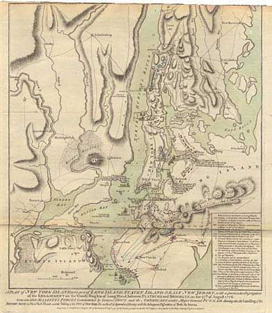
Fifth and final state of this significant Revol... (full text available to subscribers)
Item Detail
 
  MapMaker:  

William Faden


  Subject:  Colonial New York  
  Period/Size:  1776 / 18.6" x 16.6"  (47.3 x 42.2 cm)  
  Color:  Colored  
  Condition:  (B) Trimmed into neatline at top, as issued, else fine. (condition help)  
  Source:  North American Atlas  
  References:  Sellers & Van Ee #1145; Nebenzahl #12; Tooley (America) #41e, p. 76.  
 
 
Sales Information
 
  Price: 

Please register your email to view records, or sign in with email address to see records


  Offered by:  Old World Auctions  
  Catalog:  Auction No. 99 - Antique Maps, Charts, Atlases & Globes (304)  
  Lot/Item #:  221  
 
  Date:  06/2002  


Antique Maps - Valuation and Pricing, Descriptions, Resources


Home | Information | Search | Register | Contact Us | Site Map

Americana Exchange, Inc. © 1999 - 2024 Americana Exchange, Inc.. All rights reserved. OldMaps.com, the OldMaps.com logo and
AMPR are service marks or registered service marks of Americana Exchange, Inc..