Title:
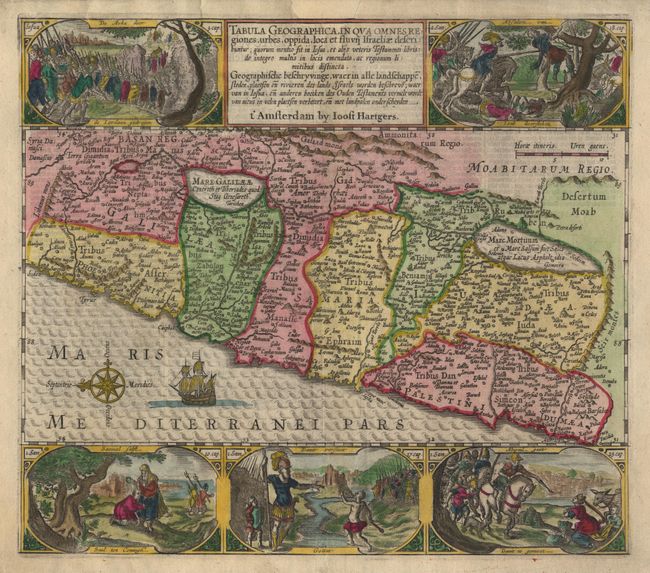
“Tabula Geographica, In Qua Omnes Regiones, urbes, oppida, loca et fluvii Israeliae describuntur”
Map Maker:
Plancius/Hartgers
A fine Bible map of the land of Canaan. This is a... (full text available to subscribers)
| Item Detail |
| |
| |
MapMaker: |
Plancius/Hartgers
|
|
| |
| |
Subject: |
Holy Land |
|
| |
Period/Size: |
1650 / 11.3" x 12.8" (28.7 x 32.6 cm)
|
|
| |
Color: |
Colored
|
|
| |
Condition: |
(B) Very expert repair of chips in margin, including one at top that intrudes slightly into map. Neatline in expert facsimile. Backed with light Japanese tissue. (condition help) |
|
| |
Source: |
|
|
| |
References: |
|
|
| |
|
|
| Sales Information |
| |
| |
Price: |
|
|
| |
| |
Offered by: |
Old World Auctions |
|
| |
Catalog: |
Auction No. 99 - Antique Maps, Charts, Atlases & Globes (304) |
|
| |
Lot/Item #: |
428 |
|
| |
| |
Date: |
06/2002
|
|
| |
| |
|
Antique Maps - Valuation and Pricing, Descriptions, Resources |
|
Home |
Information |
Search |
Register |
Contact Us |
Site Map
Americana Exchange, Inc. © 1999 - 2024 Americana Exchange, Inc.. All rights reserved.
OldMaps.com, the OldMaps.com logo and
AMPR are service marks or registered service marks of Americana Exchange, Inc..
|