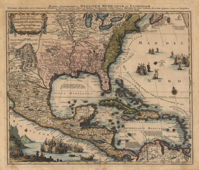
Title:
“Mappa Geographica Regionem Mexicanam et Floridam. Terrasque adjacentes, ut et Anteriores Americae Insulas, Cursius itidem et Reditus Navigantium versus flumen Missispi et alias Colonias ob oculos ponens, cura et sumtibus”
Map Maker:
Matthaus Seutter
This is one of the many copies of Delisle's import... (full text available to subscribers)
| Item Detail |
| |
| |
MapMaker: |
Matthaus Seutter
|
|
| |
| |
Subject: |
Colonial North America and Caribbean |
|
| |
Period/Size: |
1730 / 18.7" x 22.7" (47.5 x 57.7 cm)
|
|
| |
Color: |
Colored
|
|
| |
Condition: |
(B) Lightly toned with a few spots in map and some marginal flaws. (condition help) |
|
| |
Source: |
|
|
| |
References: |
Martin & Martin, p. 93. |
|
| |
|
|
| Sales Information |
| |
| |
Price: |
|
|
| |
| |
Offered by: |
Old World Auctions |
|
| |
Catalog: |
Auction No. 99 - Antique Maps, Charts, Atlases & Globes (304) |
|
| |
Lot/Item #: |
130 |
|
| |
| |
Date: |
06/2002
|
|
| |
| |
|
Antique Maps - Valuation and Pricing, Descriptions, Resources |
|
Home |
Information |
Search |
Register |
Contact Us |
Site Map
Americana Exchange, Inc. © 1999 - 2024 Americana Exchange, Inc.. All rights reserved.
OldMaps.com, the OldMaps.com logo and
AMPR are service marks or registered service marks of Americana Exchange, Inc..
|