Title:
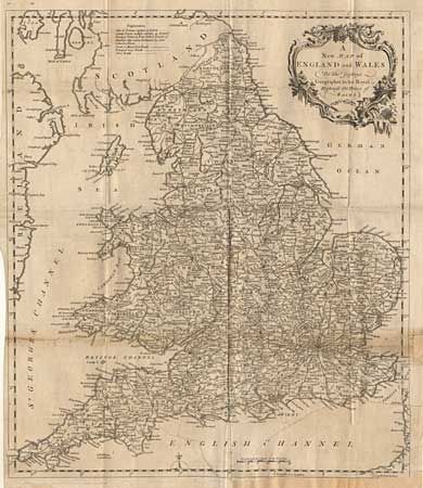
“A New Map of England and Wales by Thos. Jefferys Geographer to his Royal Highness the Price of Wales”
Map Maker:
Thomas Jefferys
Well engraved with much detail throughout the coun... (full text available to subscribers)
| Item Detail |
| |
| |
MapMaker: |
Thomas Jefferys
|
|
| |
| |
Subject: |
England & Wales |
|
| |
Period/Size: |
1772 / 17.0" x 14.5" (43.2 x 36.9 cm)
|
|
| |
Color: |
Black & White
|
|
| |
Condition: |
(C) Toned along one fold, tear to lower corner with binding loss just into neatline at lower margin. Entire map has old paper backing. (condition help) |
|
| |
Source: |
|
|
| |
References: |
|
|
| |
|
|
| Sales Information |
| |
| |
Price: |
|
|
| |
| |
Offered by: |
Old World Auctions |
|
| |
Catalog: |
Auction No. 99 - Antique Maps, Charts, Atlases & Globes (304) |
|
| |
Lot/Item #: |
341 |
|
| |
| |
Date: |
06/2002
|
|
| |
| |
|
Antique Maps - Valuation and Pricing, Descriptions, Resources |
|
Home |
Information |
Search |
Register |
Contact Us |
Site Map
Americana Exchange, Inc. © 1999 - 2024 Americana Exchange, Inc.. All rights reserved.
OldMaps.com, the OldMaps.com logo and
AMPR are service marks or registered service marks of Americana Exchange, Inc..
|