Title:
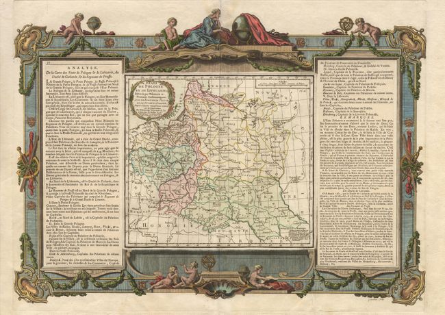
“Etats de Pologne et de Lithuanie, Divises par Palatinats et Provinces Ecclasiastiques. Avec le Roiaume de Prusse et le Duche de Curlande”
Map Maker:
Brion de la Tour/Desnos
A splendid map of Poland and Lithuania from one of... (full text available to subscribers)
| Item Detail |
| |
| |
MapMaker: |
Brion de la Tour/Desnos
|
|
| |
| |
Subject: |
Poland and Lithuania |
|
| |
Period/Size: |
1766 / 15.5" x 22.0" (39.4 x 55.9 cm)
|
|
| |
Color: |
Colored
|
|
| |
Condition: |
(A+) (condition help) |
|
| |
Source: |
Atlas General, Civil et Ecclesiastique |
|
| |
References: |
Phillips (A) #3509-28. |
|
| |
|
|
| Sales Information |
| |
| |
Price: |
|
|
| |
| |
Offered by: |
Old World Auctions |
|
| |
Catalog: |
Auction No. 99 - Antique Maps, Charts, Atlases & Globes (304) |
|
| |
Lot/Item #: |
377 |
|
| |
| |
Date: |
06/2002
|
|
| |
| |
|
Antique Maps - Valuation and Pricing, Descriptions, Resources |
|
Home |
Information |
Search |
Register |
Contact Us |
Site Map
Americana Exchange, Inc. © 1999 - 2024 Americana Exchange, Inc.. All rights reserved.
OldMaps.com, the OldMaps.com logo and
AMPR are service marks or registered service marks of Americana Exchange, Inc..
|